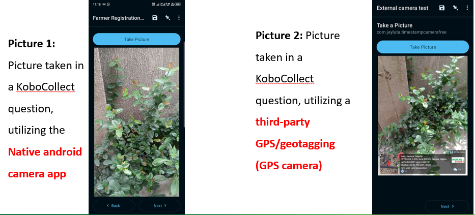
In the world of data collection, efficiency and accuracy are paramount. One powerful tool that field researchers and data collectors use is KoboCollect, an open-source Android application for primary data collection in challenging environments. One of its standout features is the ability to launch external applications, such as GPS Camera, directly from within a survey form. This functionality allows for seamless integration of advanced capabilities like geotagged photos without disrupting the flow of data collection. In this post, we’ll explore how to set up and utilize this feature to enhance your data collection process for integrity and Quality.
Use External Applications with KoboCollect?
KoboCollect is robust and versatile, but there are instances where specialized functionalities offered by other applications are required. For example, the GPS Camera app can capture photos with embedded geolocation data, which is invaluable for projects requiring precise geographic information. By integrating such applications into KoboCollect, you can enrich your data without the need to switch between multiple apps, thereby improving the efficiency and reliability of your data collection process.Data integrity is the maintenance and assurance of the accuracy and consistency of data over its entire lifecycle. GPS imprint is one-way to make data varifiable and trustworthy.
Steps to Launch an External Application from KoboCollect.
Step 1. Prepare Your Devices
- Ensure that KoboCollect and the GPS Camera app (install GPS camera from Here) are installed on your Android device.
- Verify that both applications are up to date to leverage the latest features and compatibility.
Step 2. Design Your Form in KoboToolbox or XLSform
- Open KoboToolbox and create a new form or edit an existing one.
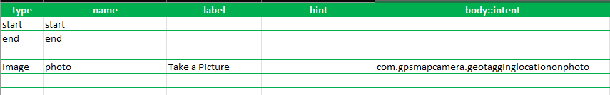
- Add an image question in your XLSForm where you want the data from the GPS Camera app to be. Call it “Capture Geotagged Photo" or anything else
- Customize the question label and hint to instruct users to take a geotagged photo.
Method 1
- In your XLSform, create a column called “body::intent”
- Enter the package name (com.gpsmapcamerastamplite.gpsmaplocationstamponphotos) of the GPS Camera app.
Method 2
- In the question’s settings, look for the option to specify an "appearance" attribute.
- Use the `ex:image` appearance to indicate that an external app will be used to capture the image.
- In the `parameters` field, specify the intent for the GPS Camera app. This will be com.gpsmapcamerastamplite.gpsmaplocationstamponphotos.
Step 3. Test Your Form
By following these steps, when data collectors reach the "Capture Geotagged Photo" question, KoboCollect will launch the GPS Camera app. After taking the photo, the image, along with its geolocation data, will be automatically saved in the KoboCollect survey form.
Benefits of Integration
- Data Quality: Capturing photos with embedded geolocation data ensures accuracy and adds valuable context to your collected data.
- Streamlined Workflow: Integrating external apps eliminates the need to switch between multiple applications, making the data collection process more efficient.
- Flexibility: KoboCollect’s ability to launch a wide range of external applications provides immense flexibility, allowing you to tailor your data collection tools to the specific needs of your project.